
A frigid blast of some of the most extreme cold on the planet is expected to surge across the U.S., stretching from the central states to the East Coast, just days before Christmas, according to a jaw-dropping new forecast.
Brace yourself — a big freeze could sweep the U.S. from the Midwest to the East Coast in the third week of December, with temperatures plunging 15 to 20 degrees below the usual average for this time of year, according to MIT climatologist Judah Cohen.
By mid-December, New York City usually hovers around 37°F. But this year? The forecast hints at something much sharper — prolonged stretches of bitter cold, with temperatures stuck in the low 20s, and even dipping into the teens.
“My thinking is that the cold the first week of December is the appetizer and the main course will be in mid-December,” Cohen told USA Today.
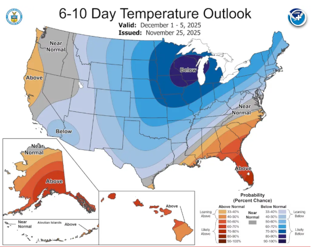
NOAA just dropped its latest temperature outlook on November 25, 2025 — and it’s catching serious attention. NOAA
"The most expansive region of most likely extreme cold on Earth stretches from the Canadian Plains to the US East Coast in the 3rd week of December," Cohen said, pointing to data generated by his latest weather modeling runs on advanced computers at MIT
That brutal surge of cold is being driven by a dramatic southward plunge of the Polar Vortex, which could dip unusually low and flood much of the U.S. with frigid Arctic air.
Just how cold it’s going to get still isn’t fully pinned down — and the impact will look very different from one region to the next. But according to Judah Cohen, most places across the U.S. could soon face temperatures even colder than what they’re enduring this week.
This week, the Midwest is bracing for highs barely climbing into the teens, with some spots topping out in the mid-20s. Meanwhile, areas from Illinois to Missouri could see bone-chilling lows hovering around 0°F.
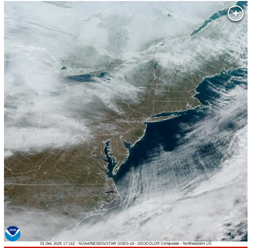
NOAA’s GOES satellite offers a breathtaking look at the Tri-State area on December 1, 2025. NOAA
Cohen’s model makes one thing clear: the East Coast is set to receive some of the coldest air on the planet relative to typical December averages later this month.
Parts of the East Coast are already feeling the first bite of this Arctic chill. The Albany area, for example, is expected to see temperatures stuck in the teens and 20s from this weekend into next week.
Those readings are roughly 15 to 20 degrees below the usual December averages for the region — a preview of the deep freeze much of the country could face later this month, Cohen said.
It’s still uncertain whether this Arctic blast will spark snow, but one thing is clear: the frigid temperatures will be ready and waiting if storm systems move in.
Winter weather swept across much of the U.S. this week, with early November snow blanketing parts of the Midwest over the weekend and throwing travel plans into chaos for thousands.
The Northeast is bracing for its first major winter storm of the season on Tuesday, as a Nor’easter barrels in, dumping snow from Pennsylvania all the way up to Maine.
Large parts of New York and New England could pick up as much as 8 inches of snow, with isolated areas in New York, New Hampshire, and Vermont seeing up to a foot, according to Fox Weather forecasts.
New York City, Boston, Philadelphia, and other coastal cities are unlikely to see much snow, instead expecting a wintry mix of morning flurries that will change over to cold rain throughout the day.
By Wednesday morning, the storm will have pushed out of the area, leaving behind colder, clearer skies.


