
Hong Kong is preparing for potential widespread damage and major disruptions as Super Typhoon Ragasa barrels toward the city, churning off the northern Philippines with fierce, tree-toppling winds.
The Hong Kong Observatory reports that the massive storm is unleashing sustained winds of up to 230 kilometers (143 miles) per hour—matching the strength of a Category 4 hurricane on the five-level Saffir-Simpson scale. Philippine authorities have issued urgent warnings of potentially life-threatening conditions.
Hong Kong’s international airport is bracing for severe disruptions as the storm bears down, with Cathay Pacific Airways Ltd. planning to cancel more than 500 flights. According to the weather agency, Ragasa could become the city’s most costly typhoon since 2018’s Mangkhut, which caused total economic losses—including insurance claims—of HK$4.6 billion (about US$592 million).
Classes will be canceled Tuesday and Wednesday, while the Hong Kong stock exchange said it is “closely monitoring” the approaching typhoon—a potential test of the city’s resolve to keep markets operating amid extreme weather.
More than 10,000 residents across Luzon, the northern Philippine island, have been evacuated as authorities suspended government offices and classes in Manila and dozens of provinces Monday. Forecasters warn that some areas could see over 200 millimeters (8 inches) of rain, raising the risk of widespread flooding and significant damage to roads and infrastructure.
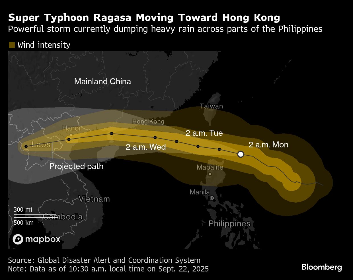
After sweeping past the Philippines—where it’s known locally as Nando—Ragasa is forecast to cross the South China Sea and skirt south of Hong Kong. The Hong Kong Observatory warns that gale-force winds will begin battering the city by Wednesday and could intensify to hurricane strength offshore.
On Monday, Hong Kong basked in clear skies and sweltering heat—the literal calm before the storm—driven by descending air along the typhoon’s outer edges. Even so, local grid operators have already launched extreme-weather response measures, including trimming trees that could topple onto power lines.
Upwelling of cooler deep-ocean waters and the rugged southern China coastline are expected to slightly weaken the storm’s winds, yet the Hong Kong Observatory says Ragasa is still on track to make landfall in Guangdong province as a typhoon on Wednesday.
Forecasters warn that Ragasa could drive dangerous storm surges as it nears the city, with water levels comparable to those during 2018’s Mangkhut, which shattered office windows across Hong Kong.
Hong Kong was already soaked by consecutive days of rain over the weekend from a separate cyclone that passed near the city. With soils saturated and drainage systems potentially blocked by debris, the arrival of Ragasa heightens the risk of landslides and sudden flash flooding.
Ragasa marks the 11th tropical cyclone to strike Hong Kong this year, setting a new record for the number of storm warning signals issued between January and September since 1946, the observatory reports. The typhoon is also expected to disrupt a two-day aviation industry conference starting Wednesday, an event that usually draws thousands of delegates to the city.
China’s Guangdong province plans to suspend rail services on Wednesday, while the cities of Zhuhai and Jiangmen will close schools and halt work. In Shenzhen, authorities are preparing to evacuate approximately 400,000 residents, state media report.
After brushing China’s southern coast, the storm is forecast to make landfall in Vietnam on Thursday as a severe tropical storm, the Hong Kong Observatory reports. Vietnam’s meteorological department has issued warnings to ships at sea about powerful winds and towering waves.
Photograph: A Cathay Pacific Airways Ltd. aircraft on the tarmac at Hong Kong International Airport in Hong Kong, China; Photo credit: Lam Yik/Bloomberg


