
Five stunning cycling routes around Zürich
This article is part of a guide to Zürich from FT Globetrotter
Cyclists are a hard tribe to like. The dedication. The smug tribalism. The uniforms: that faintly obscene and hyper-competitive Lycra-fetishism. The appalling sunglasses.
Of course, you can easily get trains further afield from Zürich (they all have ample space and reservations can easily be made online) to attempt some really challenging routes in, for example, the High Alps. But part of the magic of being a cyclist here is that you can also begin right from the city itself and be in the countryside in moments.
This is the post-work ride of choice for many Zürich cycling aficionados. It’s quick, intense and fun, an ideal early-evening lung-opener ahead of a pre-dinner sharpener. It’s also, I’m told, do-able (though I have my doubts) in an hour lunch break.
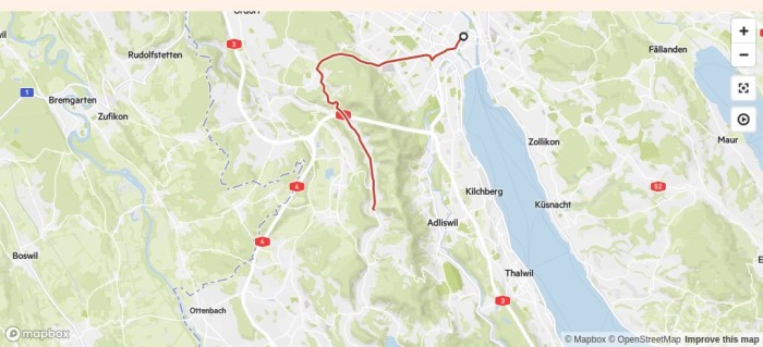
A short ride out from the city centre takes you towards the big hospital at Triemli. From here a steady, moderate uphill begins, skirting the Uetliberg — Zürich’s 870m mini-mountain — towards the prosperous suburb of Waldegg. Turning south, the route descends the other side of the ridge of hills that runs down the western side of Lake Zürich. This is a pleasant valley of meadows, pastures and dinky Swiss villages. Soon the harder work begins, as one turns off the valley road and begins a short, sharp 200m ascent through the woods to the hamlet of Buchenegg on the top of the ridge itself. At the top there are views of Zürich and the lake. All that remains is to hurtle all the way home on a more-or-less uninterrupted 13km downward journey.
In reverse, this ride is more of a challenge, while an extended version involves continuing along the valley to the Türlersee — a small lake — and then heading up the ridge over the Albis pass.
Four rivers
Distance: 43.5km
Elevation gain: 686m
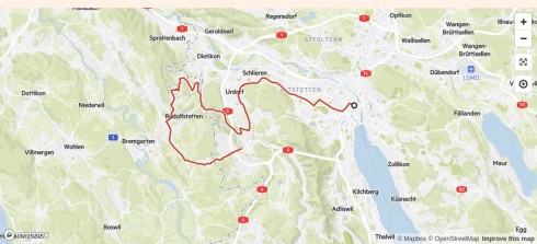
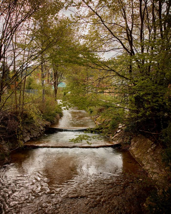
This medium-length route traverses gentle hills across the contours of the Limmat and Reuss valleys and tributaries west of Zürich, with one moderate climb halfway. It begins with a long but gentle cycle through Zürich’s suburbs towards the district of Schlieren, along the Limmat valley. Within a heartbeat the city transitions from tram stops and apartment buildings to cowsheds and pastures. Once in the countryside, it’s an easy ascent to the municipality of Birmensdorf (through which flows the Reppisch — river two, really more of a stream).
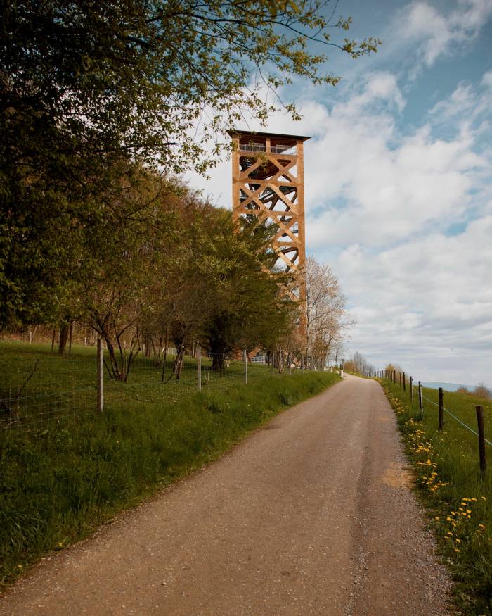
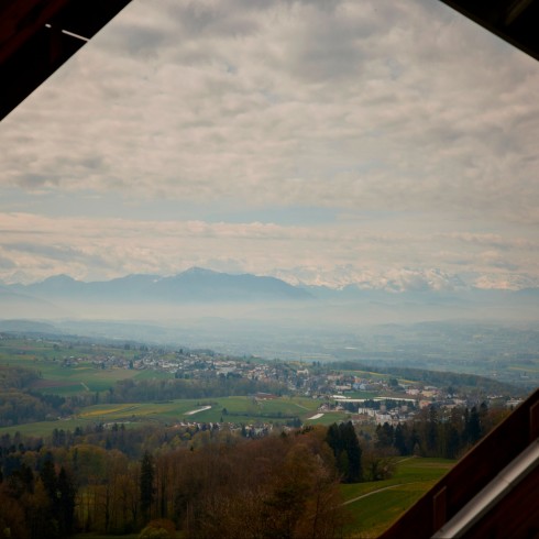
The route continues through the small military range at Bergdietikon — one of many around Switzerland that train national servicemen — and then a 250m ascent begins up Hasenberg, heading just above and parallel to the Mutschellen pass, a saddle that joins the Limmat and Reuss valleys through the village of Widen. At the crest — just short of an observation tower, the Hasenbergturm, which can be reached by a short diversion — there are glorious panoramic views westward over the Ruess, which flows down from the Gotthard pass, with the Alps rising as a backdrop to the whole scene.
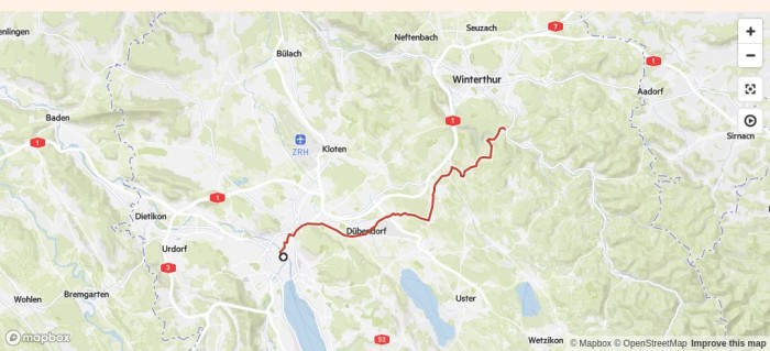
This medium-length route with two steep but short ascents explores the uplands north-east of Zürich, towards the neighbouring city of Winterthur. The highlight (and convenient midpoint) of the route is the pretty Kyburg Castle, a perfectly formed Swiss medieval redoubt with expansive views.
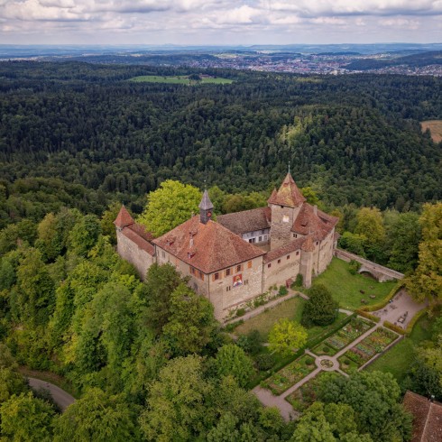
The route leaves Zürich over the Limmat river and around the Zürichberg hill towards the suburb of Dübendorf. From there, you’ll cycle through woods and past wheat fields up towards the castle. There’s a moderately challenging 180m ascent just after the town of Effretikon, before you reach the castle. As you approach the fortress, after the village of Ettenhusen, there are stunning views out across the lowlands towards Germany.

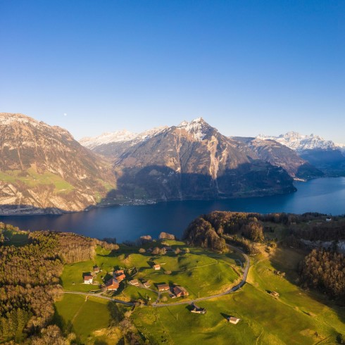
This longer tour heads south from Zürich to Zug and towards the foot of the Alps, taking in some of the stunning scenery around the Vierwaldstättersee (Lake Lucerne), one of Switzerland’s largest lakes.
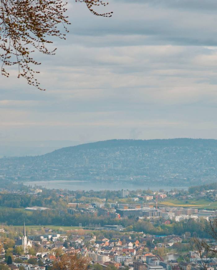
The route begins on the west coast of Lake Zürich, before crossing over the low ridge of hills just parallel to the lake that separates it from the Sihl valley at the suburb of Kilchberg. Literary cyclists may care to stop briefly at the grave of the novelist Thomas Mann, who made Kilchberg his home in his last days, before aiming for the Sihl and leaving views of Lake Zürich and its sprawling wealthy suburbs behind. It’s a steady climb along the course of the Sihl, through dark woods, to Sihlbrugg, an old valley-crossing, linking Zürich to Zug and Lucerne in the days before heavy engineering blasted quicker routes through the hills themselves.
The gradient becomes marginally steeper on the next leg, up to the village of Edlibach, above Zug itself. On the way down into Zug (the canton is a famous tax haven and the unexpected home of companies such as Glencore) there is a cluster of things to see as the route crosses the Lorze river. The ruins of the 13th-century Wildenburg castle, the striking Lorzentobelbrücke viaduct and the Höllgrotten cave complex — if a pit-stop is needed — are all just off this road.
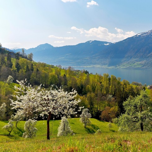
From Zug, the route continues along the eastern side of Lake Zug, through the cherry orchards for which the canton is traditionally famous. On the right, across the lake, rises the Rigi, the “Queen of the Mountains”, which is the isolated massif this route will loop right around.
Once past Arth and up a moderate set of hills, the third lake homes into view: the Lauerzersee, which is small, shallow and popular with Swiss for camping in the summer months. Looking east across it, you should have a clear view of the oddly shaped Kleiner and Grosser Mythen peaks, which Tolkien-esquely dominate this valley as it curves around to the town of Schwyz (from which the country takes its name). In the high summer, hikers climb up Grosser Mythen during the night to watch one of the most spectacular dawns in Europe, as the sun gilds the Alps with a kaleidoscopic light show.
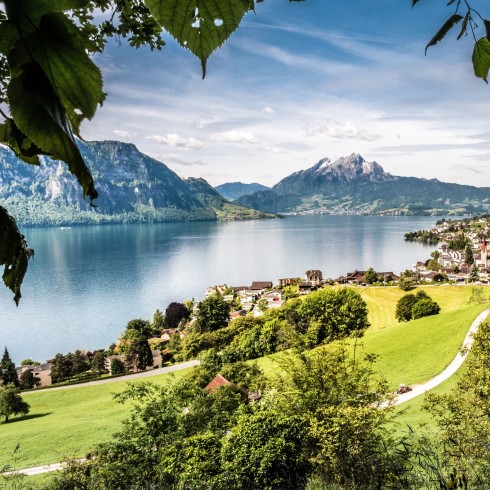
A short detour from the end of the Lauerzersee will take you into Schwyz, which has a charming old centre and is a good spot for lunch. I prefer to push on to Brunnen, however, on the shores of the fourth lake, the Vierwaldstättersee. With its grand hotels, paddle steamers and glittering Alpine backdrop, Brunnen has a distinctly Wes Anderson-like charm to it. On a hot day, jumping into the water here is very tempting. This is the halfway point.
If you do stop in Brunnen, with a bit of peering across the lake you should be able to see the Schillerstein on the opposite shore — a 30m obelisk rising from the lake water, engraved with a golden dedication to Friedrich Schiller, the German poet and William Tell playwright. Just visible a little further down the shoreline is the Rütli meadow: the most hallowed pasture in Switzerland, where, according to the Tell legend, the original oath of allegiance between the three founding cantons, Uri, Schwyz and Unterwalden, was sworn seven centuries ago (the exact date is a matter of dispute).
Leaving the town, the route traces the shoreline along the Vierwalstättersee west and north, at the foot of the other side of Mount Rigi. Things stay relatively flat as we approach the 100km point, curving back around to the other side of the Zugersee.
One challenge remains, however: a 250m ascent into the Albis hills south of Zürich, a bucolic area of rolling pastureland. After passing the fifth lake, the tiny Türlersee, comes the home stretch. A brief climb again up the Uetliberg, before coasting down back into Zürich — no more peddling needed — all the way down Birmensdorferstrasse.
Mountain passes: Gottschalkberg and Etzel
Length: 111km
Elevation gain: 1,839m
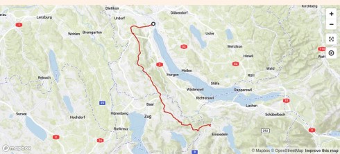
This is a challenging route with a serious midcourse ascent that heads up into the foothills of the Alps at the southern tip of Lake Zürich.
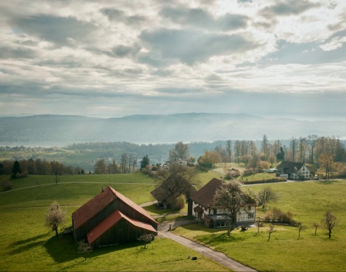
The first stage climbs out of Zürich up Birmensdorferstrasse and around the Uetliberg into the Albis hills (reversing the final stage of the previous route, the five lakes tour). It continues across the Albis chain to Sihlbrugg, crossing the river to begin the main ascent, up 630m, at times hitting 12 and 14 per cent gradients, across pastures with increasingly impressive views out over the lowlands, before entering forest to the summit of the Gottschalkenberg (1,150m). You can break the ascent halfway with a stop in the pretty village of Menzingen. At the top of Gottschalkenberg, there’s also a restaurant with typical Swiss dishes — sausages, schnitzels and a selection of huge salads — that is a good place to break for lunch.
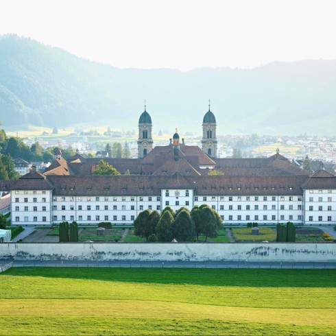
The route swoops down from this summit, past tiny village ski areas to the town of Einsiedeln, which is famous for its large monastery. A causeway then stretches out across the middle of the Sihlsee to the east side of the lake. Another steep series of hairpins takes you to the top of the Etzel mountain (almost). By the tiny chapel of St Meinrad (erstwhile home of the hermit martyr, killed in 861, to whom Einsiedeln is dedicated), there is an excellent Gasthaus with a lovely terrace. It’s a nice spot for lunch, with slightly more refined dishes than the average pit-stop — if you’ve held out until this point.
From here, a steep descent takes the route on to the uplands above the southern curve of Lake Zürich, through a series of pretty villages before descending down to Sihlbrugg and to the Sihl valley. It’s then a simple question of just following the Sihl — more or less gently downhill all the way — as it flows back towards Zürich.
Share your favourite cycling routes in and around Zürich in the comments. And follow FT Globetrotter on Instagram at @FTGlobetrotter
Cities with the FT
FT Globetrotter, our insider guides to some of the world’s greatest cities, offers expert advice on eating and drinking, exercise, art and culture — and much more
Find us in Zürich, Melbourne, Hong Kong, Tokyo, New York, London, Paris, Rome, Frankfurt, Singapore, Miami, Toronto, Madrid and Copenhagen
This story originally appeared on: Financial Times - Author:Sam Jones


